Planning and Zoning Director: Shelly Johnston
ShellyJohnston@TownofForestCity.com 828.247.4412

The Planning and Zoning Director is responsible for the day-to-day administration of the zoning ordinance and code enforcement. They also review all zoning permits, rezoning requests, special use permits and residential group developments before permits are issued. The Planning and Zoning Director also provide technical assistance to the Forest City Board of Planning and Adjustment. This position also serves to review and verify all plat and parcel surveys prior to recordation by the Rutherford County Register of Deeds office. These plat reviews may take up to 48 hours in order to ensure city ordinance regulations, as well as state regulations are met.
The Code Enforcement and Development Department, along with the Forest City Police Department, work together to enforce local ordinances to reduce the number of abandoned vehicles, junk vehicles, overgrown grass, trash, debris, unsafe buildings and many more ordinances within the city limits.
Unified Development Ordinance (as amended December 8, 2025)
Town of Forest City Code of Ordinances
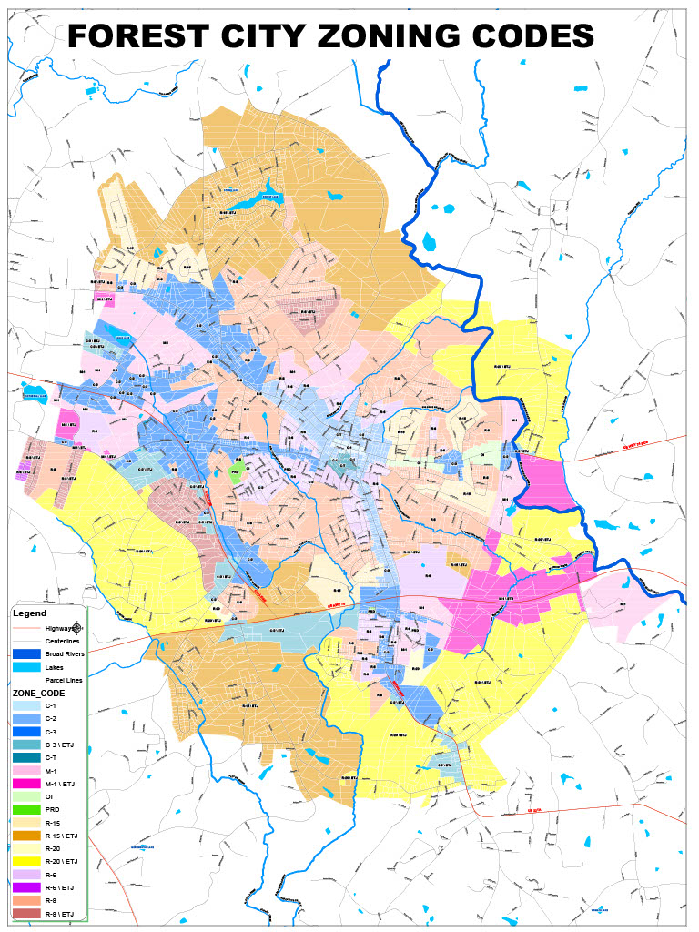
Town of Forest City Zoning Map (2020)
Town of Forest City Comprehensive Land Use Plan
Board of Planning and Adjustments Meeting and Hearing Information
Meetings are held the first and third Thursday of each month. Meetings will be held at the Main Street Meetings Building, located at 108 E. Main Street, unless otherwise posted.
Cut off for zoning applications are the 30th day before the meeting date. You can find a full list of meetings and agendas here.
Setbacks according to Zoning District:
| DISTRICT | FRONT SETBACK (feet)2 | SIDE SETBACK (feet)2 | REAR SETBACK (feet)2 | MAX HEIGHT (feet) |
|---|---|---|---|---|
| R-20 | 35 | 10 | 15 | 35 |
| R-15 | 35 | 10 | 15 | 35 |
| R-8 | 25 | 10 | 10 | 35 |
| R-6 | 20 | 10 | 10 | 35 |
| O-1 | 20 | 10 | 10 | 35 |
| C-1 | N/A | N/A | N/A | 60 |
| C-2 | N/A | N/A | N/A | 60 |
| C-3 | 35 | N/A | N/A | 60 |
| M-1 | 35 | 20 | 20 | 60 |
Do you live in the Town of Forest City's jurisdiction?
The Town of Forest City is comprised of 8 square miles, and an Extra Territorial Jurisdiction (ETJ). The link below, will connect you to the Rutherford County GIS Map, which will assist in verifying if your property address is located in the Town of Forest City, Forest City's ETJ, or the jurisdiction of the Rutherford County Planning and Building Inspections Departments.


